Showing posts with label Lake. Show all posts

Sunday, July 4, 2021

Tso Kar Lake


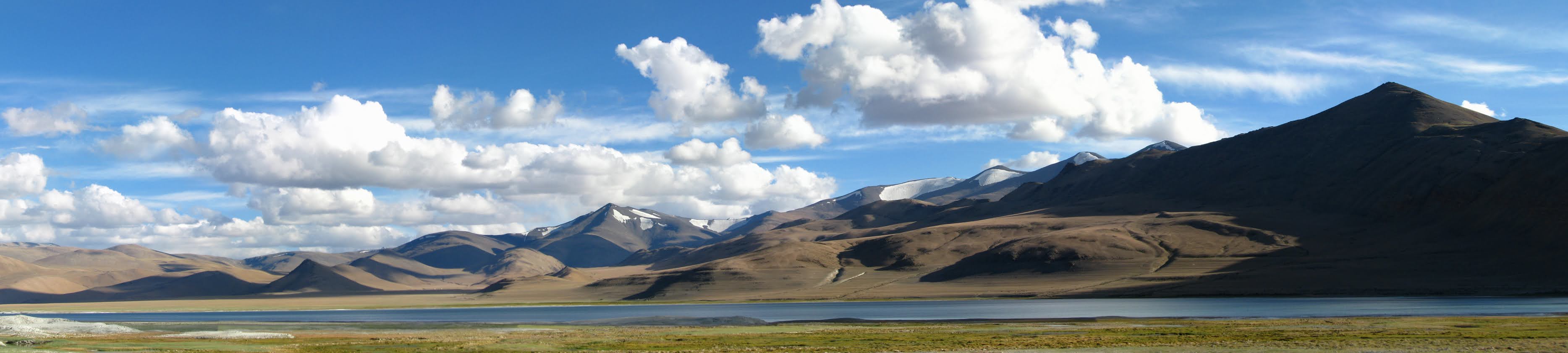
 The Tso Kar is a fluctuating salt lake known for its size and depth situated in the Rupshu Plateau and valley in the southern part of Ladakh in India. Tso Kar lies 160 km south of Leh; the Leh Manali road passes 30 km west of it.

It is called Tso Kar, meaning white lake, because of the white salt efflorescence found on the margins due to the evaporation of highly saline water.

It is connected by an inlet stream at its south-west end to a small lake, Startsapuk Tso, and together they form the 9 km2 More plains pool, which is dominated by the peaks of two mountains, Thugje (6050 m) and Gursan (6370 m). From the geology of the More Plains, it can be concluded that the Tso Kar in historical times ranged up to this high valley. Until a few years ago the lake was an important source of salt, which the Changpa nomads used to export to Tibet. The nomadic settlement of Thugje is located 3 km in the north. There is a tented camp on the west bank of the lake which provides accommodation for tourists.

Due to the high altitude, the climate is extreme in the winter; temperatures below -40 °C are not uncommon. In the summer the temperature rises above 30 °C (86 °F), with extreme fluctuations during the day. Precipitation in the form of either rain or snow is extremely rare


The inlets of the Tso Kar are a source of non-saline water; pondweeds and basic nettles grow there, forming floating islands of vegetation in the spring and dying off in the winter. Sedge and large numbers of buttercups grow on the shores of Startsapuk Tso and of the tributaries of the Tso Kar, while some parts of the high basin are marked by steppe vegetation interspersed with tragacanth and pea bushes. The shore of Tso Kar is partly covered with a salt crust, which keeps vegetation away from the inflows.

Due to the salinity of the Tso Kar, most of the resident fauna is found in its tributaries and in Startsapuk Tso. There are large breeding colonies of grebes and brown-headed gulls, and some strip geese, rust geese and terns. In the vicinity of the lake black-necked cranes and Tibetan grouse are relatively common. The basin of the Tso Kar and the adjoining More Plains constitute one of the most important habitats of the kiang, Tibetan gazelles, Tibetan wolves and foxes; there are himalayan marmots in the higher reaches. Yaks and horses are kept by the nomads.

Currently the lake basin has no special protection, but there are plans to include it within a national park which may be established in the highlands of south-eastern Ladakh


Tsokar has been added as the 42nd Ramsar site, a conservation status conferred by International Ramsar Convention on Wetlands.

The Tso Kar Basin is a high-altitude wetland complex, consisting of two principal waterbodies:

  • Startsapuk Tso, a freshwater lake of about 438 hectares to the south,
  • Tso Kar itself, a hypersaline lake of 1800 hectares to the north,
  •        situated in the Changthang region of Ladakh.
    It is an A1 Category Important Bird Area (IBA) as per Bird Life International and a key staging site in the Central Asian Flyway.
    This high-altitude wetland complex is found at more than 4,500 metres above sea level in the Changthang region of Ladakh. The complex includes two connected lakes, the freshwater Startsapuk Tso and the larger hypersaline Tso Kar; it presents a notable example of two such lakes existing in close proximity. The name Tso Kar refers to the white salt efflorescence on the margins of the lake caused by the evaporation of the saline waters. The local climate is arid, and glacial meltwater is the primary water source for the lakes. The lakes and in particular the presence of fresh water attract biodiversity in a biologically sparse region. Inhabiting the Site are numerous threatened species including the endangered saker falcon (Falco cherrug) and Asiatic wild dog or dhole (Cuon alpinus laniger), and the vulnerable snow leopard (Panthera uncia). The Site also acts as an important stopover ground for migratory birds along the Central Asian Flyway and is one of the most important breeding areas in India for the black-necked crane (Grus nigricollis).

    Administrative region: 

    Nyoma Block, Leh District, Union Territory of Ladakh.It is also recognised as India's 42nd Ramsar site.

    https://rsis.ramsar.org/ris/2443

    Read More

    Tsomoriri Lake


    Tso Moriri is a lake in the Changthang Plateau (literally: northern plains) in Ladakh. The lake is at an altitude of 4,522 m (14,836 ft). It is the largest of the high altitude lakes entirely within India and entirely within Ladakh in this Trans-Himalayan biogeographic region. It is about 16 miles (26 km) north to south in length and two to three miles (3 to 5 km) wide. The lake has no outlet at present and the water is brackish though not very perceptible to taste. The lake and surrounding area are protected as the Tso Moriri Wetland Conservation Reserve.
    The lake is fed by springs and snow-melt from the adjacent mountains. Most water enters the lake in two major stream systems, one entering the lake from the north, the other from the southwest. Both stream systems include extensive marshes where they enter the lake. It formerly had an outlet to the south, but this has become blocked and the lake has become an endorheic lake. The lake is oligotrophic in nature, and its waters are alkaline.
    Accessibility to the lake is largely limited to summer season, though Karzok on the northwest shore and the military facilities on the eastern shores have year-round habitation.
    As per a classification of the Himalayan Lakes done on the basis of their origin, there are four groups and Tso Moriri falls under the third group of "remnant lakes". The classification as reported states

    1.  Glacial lakes which are formed in and around glaciers
    2.  Structural lakes, formed by folds or faults due to movements in earth’s crust (e.g. Nainital lake in Uttarakhand),
    3.  Remnant lakes which were originally structural but represent the remnants of vast lakes (e.g., Tso Moriri, Tso Kar, Pangong Tso in Ladakh, and Dal Lake in Kashmir)
    4. Natural dammed lakes i.e., temporary water bodies formed along the river courses due to deposition of rocks or debris e.g. Gohna Tal in Garhwal, Uttarakhand
    The lake is 20 to 50 kilometers southeast of the elevated valley of the core Rupshu Valley and falls within the greater Rupshu Plateau and valley area. The lake is ringed by mountains rising over 6,000 m (20,000 ft), including Mentok Kangri and Lungser Kangri. "Changpa", the nomadic migratory shepherds (pastoral community) of yak, sheep, goat, and horses of Tibetan origin and who are engaged in trade and work on caravans in Ladakh region, are the main inhabitants of the area. Changpa (Champa) herders use the land of this valley as grazing ground and for cultivation

    The Working Report (2006) of the Planning Commission of the Government of India also reports:

    Despite a poor vegetation cover, relatively low standing biomass and high anthropogenic pressure, this area sustains a considerably high livestock population. Steady increase in the livestock population in the area is mainly attributed to influx of nomadic herders from Tibet during recent decades and promotion of Pashmina goat production by the Animal Husbandry Department (AHD) for fine quality under wool (Pashmina). The herders and AHD officials, in recent years have begun to raise concern over degradation of pastures, resultant shortage of forage, and mass mortality of livestock during severe winters.

    The Korzok Monastery, on the western bank of the lake is 400 years old and attracts tourists and Buddhist pilgrims. Tourism during May – September attracts large number of foreign and local tourists even though tented accommodation is the facility available, apart from a small PWD guest house close to the Lake. Northeast of Tso Moriri is a small lake which is known locally as Lake of Joy.


    The lake, with water spread area of 120 km2 (46 sq mi) is enclosed by peaks exceeding 6,000 meters on both the east and west sides. On the south, a nearly flat valley connects with but does not drain into or out of the Pare Chu river which is part of Sutlej river basin. Lingdi Nadi, major tributary of Tso Moriri, drains western catchment area of the lake and joins the lake on its south side.[8] This valley contains the Nuro Sumdo wetlands (with a catchment area of 20 km2 or 7.7 sq mi), a boggy area that mostly drains into the Pare Chu. Several small mountain streams feed the lake, including one through pasture land at Peldo Le. The lake is fed by springs and snow melt and has a maximum depth of 40 m (130 ft). Aridity and cold desert conditions prevail in the lake region; with summer temperature varying from 0° to 30 °C (32° to 86 °F) and winter temperature recording −10° and −40 °C (14° to -40 °F). Geologically the lake is in Ordovician rock


    Avifauna

    • Thirty-four species of birds included 14 species of water birds (some are pictured in the gallery) of which following are the vulnerable species
      • Black-necked cranes (Grus nigricollis) endangered.
      • Bar-headed geese (Anser indicus)– only breeding ground in India
      • Brown-headed gulls (Larus brunnicephalus)
      • Great crested grebe (Podiceps cristatus)
      • Ferruginous pochard
      • Black-necked grebe (Podiceps nigricollis)

    Mammals

    • Tibetan gazelle, Procapra picticaudata, Goa antelope (threatened)
    • Eurasian lynx
    • Nayan Ovis ammon hodgsoni
    • Bharal (Pseudois nayaur) Himalayan blue sheep
    • Tibetan Ass (Kiang) or Equus kiang, endemic to the Tibetan Plateau
    • Great Tibetan Sheep
    • One species of marmot, Marmota himalayana in large numbers seen on the hill slopes surrounding the lake and also along the roadsides
    • One species of hare, Lepus oistolus
    • One species of vole, Alticola roylei
    • Three species of mouse hares, Ochotona macrotis, Ochotona curzoniae or Tibetan sand fox and Scincella ladacensis
    Large carnivores
    • Carnivores fauna reported are:
      • the snow leopard (Uncia uncia)
      • the Tibetan wolf (Canis lupus chanco)


    Threats to the lake

    There are a number of threats to the Lake, such as:

    • Increase in the number of tourists visiting the lake affecting the breeding of avifauna
    • Additional road construction along the lake
    • Pasture degradation affecting wildlife, particularly wild herbivores (marmots, hares, ungulates)
    • An increase in the grazing of sheep in the wetlands surrounding the lake
    • The absence of a proper garbage disposal facility at the lake.
    • Dogs kept by the people who live near the lake are known to attack the cranes and destroy their eggs.
    • Jeep safaris have been known to chase wildlife such as kiang and approach close to the breeding ground.
    • Lack of regulations and monitoring by the government


    Ramsar site

    Largely based on the ecological diversity of the Lake (explained in the previous section) and its surroundings, the Tsomiriri was notified in November 2002 under the List of Ramsar Wetland sites under the Ramsar Convention. The justification could be summarized as

    • The faunal collection is unique and has a large variety with endemic and vulnerable species
    • The herbivore species are also endemic to the region
    • The lake plays a fundamental role as breeding grounds and key staging posts on migration routes for several water birds belonging to six families, which is distinctive of wetland diversity and productivity


    Tsomoriri. 19/08/02. Jammu & Kashmir. 12,000 ha. 32°54'N 078°18'E. Wetland Reserve. A freshwater to brackish lake lying at 4,595m above sea level, with wet meadows and borax-laden wetlands along the shores. The site is said to represent the only breeding ground outside of China for one of the most endangered cranes, the Black-necked crane (Grus nigricollis), and the only breeding ground for Bar-headed geese in India. The Great Tibetan Sheep or Argali (Ovis ammon hodgsoni) and Tibetan Wild Ass (Equus kiang) are endemic to the Tibetan plateau, of which the Changthang is the westernmost part. The barley fields at Korzok have been described as the highest cultivated land in the world. With no outflow, evaporation in the arid steppe conditions causes varying levels of salinity. Ancient trade routes and now major trekking routes pass the site. The 400-year-old Korzok monastery attracts many tourists, and the wetland is considered sacred by local Buddhist communities and the water is not used by them. The local community dedicated Tsomoriri as a WWF Sacred Gift for the Living Planet in recognition of WWF-India's project work there. The rapidly growing attraction of the recently opened area to western tourists (currently 2500 per summer) as an "unspoilt destination" with pristine high desert landscapes and lively cultural traditions brings great promise but also potential threats to the ecosystem. Ramsar site no. 1213. 
    Read More

    Tuesday, August 4, 2020

    Pangong Lake


    Pangong Lake, situated at a height of almost 4,350m, is the world’s highest saltwater lake. Its water, which seems to be dyed in blue, stand in stark contrast to the arid mountains surrounding it. Extending to almost 160km, one-third of the Pangong Lake lies in India and the other two-thirds in China.


    Pangong Lake, one of the most famous lakes in Leh Ladakh, derives its name from the Tibetan word, “Pangong Tso”, which means “high grassland lake”. You could spend hours in contemplation here, and still not have enough of its beauty. Pangong Lake is also known to change colors, appearing blue, green and red at different times.

    The eastern part of the lake is fresh, with the content of total dissolved solids at 0.68 g/L, while the western part of the lake is saline, with the salinity at 11.02 g/L.The brackish water of the lake has very low micro-vegetation. Guides report that there are no fish or other aquatic life on the Indian side of the lake, except for some small crustaceans. On the other hand, visitors see numerous ducks and gulls over and on the lake surface. There are some species of scrub and perennial herbs that grow in the marshes around the lake.

    The lake acts as an important breeding ground for a variety of birds including a number of migratory birds. During summer, the Bar-headed goose and Brahmini ducks are commonly seen here. The region around the lake supports a number of species of wildlife including the kiang and the marmot. The lake hosts large quantities of fish, especially Schizopygopsis stoliczkai and Racoma labiata. Freshwater snails of the genus Radix also live in the lake.

    Formerly, Pangong Tso had an outlet to Shyok River, a tributary of the Indus River, but it was closed off due to natural damming. Two streams feed the lake from the Indian side, forming marshes and wetlands at the edges. Strand lines above current lake level reveal a 5 m (16 ft) thick layer of mud and laminated sand, suggesting the lake has shrunken recently in geological scale. On the Indian side, no fish have been observed, however in the stream coming from South-eastern side (Cheshul nalla), three fish species (Schizopygopsis stoliczkae, Tibetan stone loach and Triplophysa gracilis) have been reported (Bhat et al., 2011). The low biodiversity has been reported as being due to high salinity and harsh environmental conditions (Bhat et al., 2011).

    Bird Islet is the most famous island in Pangong Tso.


    Read More

    Search

    Labels

    © 2020 KnowLadakh. Designed by KnowLadakh
    Powered by Blogger.